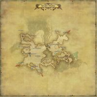
Eastern Thanalan
Eastern Thanalan
- Type
- Zone
- Zone
- Thanalan
(Aldenard) - Connects to
- Central Thanalan (W)
Southern Thanalan (S)
South Shroud (NE) - Aetherytes
- Camp Drybone (X:13.8, Y:24.3)
“Eastern Thanalan borders the Black Shroud, and is divided north from south by the Yugr'am River. From the many dead buried in the Church of Saint Adama Landama's lichyard to the towering formations of corrupted crystal, one is ever reminded of the Seventh Umbral Calamity's devastation in this region.
— In-game description
Eastern Thanalan is a zone in Thanalan.
Locations
| Area | Points of Interest |
|---|---|
| Wellwick Wood | |
| The Burning Wall | |
| Sandgate | |
| Camp Drybone |
|
| Drybone |
Activities
Shops & Services
| Merchant Name | Merchant Location |
|---|---|
| Chachamun | (X:22.3, Y:21.3) |
| Junkmonger | (X:13.8, Y:23.3) |
| Merchant & Mender | (X:13.3, Y:23.4) |
| Merchant & Mender | (X:10.8, Y:16.7) |
| Shopkeep | (X:13.8, Y:24.8) |
Enemies
Normal
- Tuco-tuco
- Myotragus Billy
- Myotragus Nanny
- Blowfly Swarm
- Rotting Corpse
- Rotting Noble
- Vandalous Imp
- Amalj'aa Hunter
- Amalj'aa Javelinier
- Amalj'aa Ranger
- Amalj'aa Bruiser
- Chasm Buzzard
- Bumble Beetle
- Phurble
- Axe Beak
- Bandit Archer
- Bandit Mage
- Bandit Trapper
- Qiqirn Roerunner
- Quartz Doblyn
- Golden Fleece
- Mirrorknight
